The Erwood Crossing
(Rewritten January 2021)
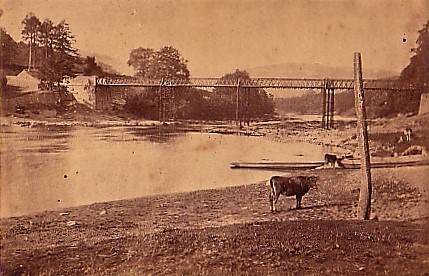
The best view of the Wye-crossing at Erwood is from the Radnorshire side, where “Glan yr Afon” stands overlooking the water. Now owned by Peter & Caroline Horsburgh, this riverside house used to be known as The Boat Inn – a tin plate with that name on was still nailed to the telegraph post at the roadside until two years ago. The various incarnations of The Boat can be seen in #1, #2 and #3. #1 is taken in the late C19, #2 in 1963 by a friend on honeymoon and #3 is how it looks today. What extraordinary transformations…
The crossing is famous for a tragic little story that emerged in a local newspaper in the 1930's; I just wish I knew how true it was. (But it's become such a deep-seated part of the history of the area that I shall not dispute it.) It refers to a time before the first bridge was built across the Wye in 1861 and Caroline tells it well: Twm and his son owned The Boat Inn and a ferry – well, a wooden box on a loop of rope that could carry 3 or 4 cattle would be a better description – which was hauled across the Wye when the river was too full to cross on foot. Twm & Son stayed on the Epynt side in what became known as Caban Twm Bach (Little Tom's Cabin), probably praying for rain to prevent the herds being able to walk or swim across. One day when their prayers were answered the swirling water caused one of the beasts on board to panic and capsize the ferry. The drovers on board grabbed the animals' tails and were pulled to land. Twm, however, didn't know that trick and was drowned.
If someone can find a parish record in the area that records this, please tell me. I couldn't. In 1865 Edward Jarmyn, a smith, was drowned trying to cross the Wye in the wrong place while drunk, but that is all.
Then Caroline told me that her daughters, when roughly 10 and 12, went for a swim in the Wye and the younger one hurt her foot on something hard sticking up from the river-bed. The elder dived down to see what had hurt her and there, screwed into the bedrock, was a large eye-bolt/iron ring. What use could that have had but for threading a ferry-rope through?
The story gets more confusing because of the census returns. David & Sarah Evans are listed in the 1841 Census for Llandeilo Graban as keeping the “Twm Boat”. What sort of hybrid is that? Then, ten years later, they reappear as innkeepers of “Caban Twm Bach”. The name seems to have stuck because the 1861 Census records a Thomas Evans as innkeeper of the “Cavan Twm Bach”. My guess is that "The Boat" was gradually replaced by "CTB" in honour of Twm, the local legend & hero. This would explain the variety of names on the censuses.
In October 2016 Mike Jones emailed me to say that, years before, his great-aunt Ellie had sent the story of Twm Bach to the local paper and had told Mike that Twm was his x8 great-grandfather, which would put the date of the drowning – at a guess – in the first quarter of the C19.
Did Twm run the pub as well as the ferry? Probably. And did it carry on without Twm? Yes, it was used by an angler in 1852 whose fishing trip appeared in the Herefordshire Gazette.
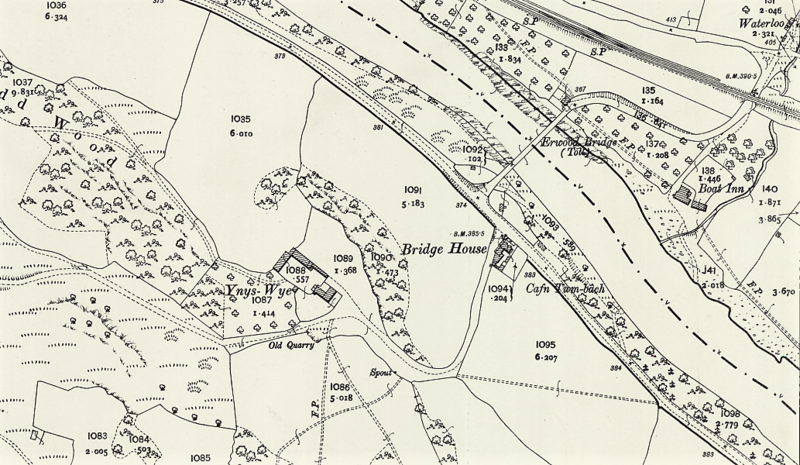
But here a horrible double-meaning enters, to confuse us: cafn is also an angling term used on Welsh rivers to mean a salmon lie or resting place, in other words a good place to catch a salmon. And the Wye at Glan yr Afon has a salmon pool stretching downriver from the bridge...however, I cannot believe that a) OS maps are aimed at fishermen and b) that if they were, they would print the word on top of the riverbank, where it is meaningless (see #5).
#4 shows the first bridge, opened in the 1860's – roughly 100 years before the modern one. Remains of the two great concrete buttresses that supported it at either end are still there today. Three pine trees, easily visible by drovers coming down Epynt, mark the bridge and there was a little tollhouse the RH side, not visible in the picture. But the picture is misleading in that the white building on the LH side is not up against the bridge, as it appears to be. In fact, according to the 1880's 25” map (#5), there shouldn't be any house near the bridge at all! Thanks, Peter, for the superb picture, but it's extremely confusing… So much so that I thought for a moment that we were seeing the bridge from the North West rather than the South East, but that doesn't make sense either.
…and to make it more so, in the 1841 Census, Mary Kneal? – the enumerator had atrocious writing – was shopkeeper at Bridgend; in 1851 Bridgend Inn is mentioned in a newspaper; in 1860 another newspaper mentions Bridge End [two words] Inn, run by a David Jones.
At first sight there is no "Cavan" near the legend. But, as Peter points out, above the legend there is a long s (~ on its side), presumably the sign for "gate", leading to a long field which encloses, at the far end, a small building. Cabin found at last.
* * * * * *
In April 2019 I was told by historians in Painscastle that the cruelly steep hill/bank above Glan yr Afon would not have been the drovers' preferred route. Instead they would have crossed the “Boat Fields” due east of the inn; past The Skreen and along the bottom of Twyn-y-Garth before turning north-east to Penisarplwyf to join the Painscastle road – unless the missed out Painscastle altogether and crossed The Begwns to Rhydspence.